Color infrared imagery is useful in learning about the health status of leafy plant material. But can it be used to selectively harvest wine grapes, separating a block into different lots for winemaking purposes?
In a previous article in Good Fruit Grower, I described what color infrared imagery is and what it detects (see the August 2005 issue). The proportions of light reflected back in the visible and near infrared wavelengths (just beyond the visible light we can see) tell us something about the amount of leafy plant material. The more reflectance we measure in the near infrared bands, the greater the amount of healthy plant material.
In the case of wine grapes, more isn’t necessarily better. More vigorous vines shade fruit, producing larger berries with lower Brix and delayed ripening, and a tendency toward vegetal flavors. Less vigor tends to be a more stressed vine with smaller berries, fruity flavors, higher Brix, and earlier ripening. Ste. Michelle Wine Estates of Washington State was interested to see if remote sensing could provide information on canopy density and hence grape maturation, providing the winemakers with the flexibility to blend these different characteristics together when creating their wines.
A creative collaboration among the Washington State University’s Center for Precision Agricultural Systems (WSU-CPAS), Ste. Michelle, and Infrared Image Solutions, Inc., of Hermiston, Oregon, allowed us to explore this question. Through this collaboration, the center has been able to transfer expertise and technology in remote sensing now being used by Ste. Michelle for harvest planning and other tasks. Because of their investments in personnel and technical resources (such as Geographical Information System software), Ste. Michelle was able to utilize these new information sources.
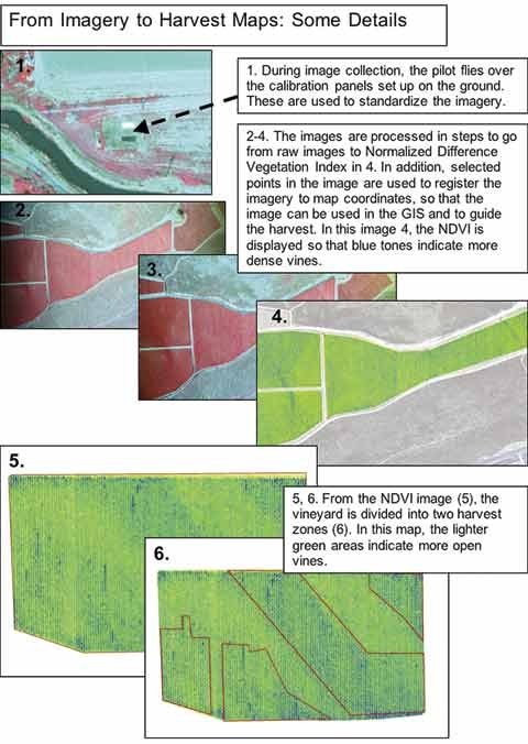
In 2003, Washington State University Center for Precision Agricultural Systems integrated a multispectral camera with a small PC, wireless mouse and keyboard, and flat screen monitor. The system was designed to fit into the tight space next to the pilot (where the front passenger seat would be) in a small fixed-wing aircraft. The pilot can control the data collection software with the wireless mouse while flying, and view the imagery in real time. In order to correct the imagery for changes in sun angle and camera settings, WSU-CPAS developed a calibration panel system, which is deployed on the ground (see “From Imagery to Harvest Maps). The pilot flies over the panels before or after flying over the vineyards. The calibration panels have known reflectance properties, which we determine by other independent measurements, and these values are used to convert the imagery on each day to uniform reflectance values. Infrared Image Solutions provides the aircraft and pilot to take images over orchards and vineyards using this system.
The calibrated imagery is used to create Normalized Difference Vegetation Index (NDVI) maps. Higher values of NDVI in the image correspond to greater vine canopy density in the vineyard. Initially, WSU-CPAS provided Ste. Michelle with processed imagery that could be downloaded into their Geographical Information Systems (GIS) database. The company now manages the GIS database and performs all the necessary image processing in house.
So far, the technology is proving valuable. The NDVI maps are generated with two classes or zones, which are used to guide the selective harvest. Two gondolas are run in tandem, with the grapes from vines in the lower NDVI zone (more mature) going into a separate load.
The 2005 harvest demonstrated that the selectively harvested grapes make premium wines and provide the winemakers with more blending options. Ste. Michelle plans to expand the selective harvesting into more of their vineyards for the 2006 season. As large companies like Ste. Michelle make initial investments in this technology, WSU-CPAS hopes that other growers will be able to take advantage of these technology developments.
Leave A Comment