The cold air surge expected to hit Eastern Washington on Friday and continuing through the weekend could be particularly damaging to stone fruit orchards in central and southern regions of the state as they are approaching bloom and, therefore, highly vulnerable to cold.
“An arctic airmass of this magnitude is highly unusual for mid-March, and the impacts to emerging perennial crops will be especially severe as a result of the recent stretch of mild early-spring weather. The combination of cold, dry air and strong winds on Friday and Saturday night will make it especially challenging to mitigate cold damage,” Craig Oswald and Joe Zagrodnik with Washington State University’s AgWeatherNet told the Good Fruit Grower in an email.
When factoring in winds and the dew point to the forecast temperatures, it could be difficult for growers’ mitigation measures to sufficiently protect buds.
“Friday night temperatures look to dip into the mid-20s for southern Washington, near 20 for northern Washington, and the low 30s for western Washington,” they continued. “Dew points will drop to the single digits to mid-teens for most of eastern Washington by Saturday evening. Saturday night will be the coldest night with temperatures dropping to the teens to low 20s across southern and central Washington. Sunday night will likely be cold as well, although a more typical radiative cooling night is expected with calm winds, clear skies and higher dew points than Saturday night.”
The extreme cold event coincides with a spate of warm weather resulting in trees breaking dormancy several weeks earlier than average.
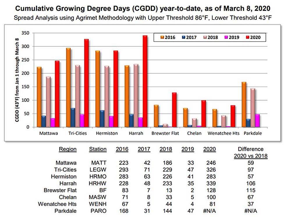
Based on degree days, it’s the earliest season Washington cherry growers have seen in decades, said B.J. Thurlby, president of the Washington State Fruit Commission, in a presentation to the commission board on Wednesday.
“We’re starting way ahead of every warm year we’ve had,” he said.
Some trees in the Tri-Cities area already sustained cold damage in February, due to the early dormancy break, board member Jim Kelly said. Temperatures are forecast to go much lower this weekend, so for trees “about ready to pop, there’s going to be casualties, no doubt,” he said at the meeting.
More details about the forecast and bud cold hardiness are available on AgWeatherNet at https://weather.wsu.edu
—by Kate Prengaman


Leave A Comment