David Brown
Precision agriculture, or site-specific crop management, is widely used in field crops. Now, Washington State University scientists are wondering how orchardists might also benefit from new monitoring technologies.
Precision agriculture involves observing, measuring, mapping, and managing variability in a farm. It relies heavily on sensors, along with Global Positioning Systems or Geographic Information Systems, in order to map the variability of the terrain, organic matter content, moisture levels, and nitrogen levels, for example, as well as areas where plants are stressed.
Producers can then manage the farm in zones, based on their specific needs, in order to optimize production. Management impacts can be assessed through yield monitoring.
The ultimate aim is to develop a decision support system to improve efficiency and optimize returns, while conserving resources.
Precision agriculture does not involve intensively managing tree growth and precisely training limbs, for example. That would be precision horticulture.
Dr. David Brown, soil scientist with WSU in Pullman, works primarily with growers of wheat and other annual crops. But this summer, he’s been talking to orchardists about the potential for using precision agriculture.
What he learned was that growers are using some precision management techniques, but on an ad hoc basis to address specific issues such as soil moisture, rather than as part of an overall system. Brown said there is much more information that could be gathered that would be useful to fruit growers, and he was surprised that, given the high value of the crop, most growers are not using remote sensing. (See “Precision ag: Specialized tools” for more information on the various types of monitoring possible.)
The technologies are readily available and would be inexpensive in relation to the value of the crop, Brown said. “I think orchardists are just not aware of these things. These are very simple to do, and yet no one has really worked on them.”
One reason is that the scientists with the most expertise in precision agriculture tend to be focused on annual crops and know little about tree fruit or grape production. WSU no longer has a soil scientist working in tree fruits, and research on orchard soils has been “shockingly limited,” Brown said.
Conversely, people who know about orchards don’t necessarily know a lot about soils and precision ag.
He and David Granatstein, WSU sustainable agriculture specialist, had hoped to bring together leading soil scientists from around the country, if not the world, for a workshop focusing on soil research in perennial fruit crops.
“We want to try to get some attention on this,” Brown said. “We want to boost interest in this area. We have to articulate the benefits and how we see the soil scientists helping the industry. That requires putting our heads together.”
They applied for a planning grant from the Specialty Crop Research Initiative to cover the cost of the meeting, but were not funded.
Meaningful
Collecting the data is relatively simple, but the difficult part is processing the data so that it is meaningful to the grower, Brown said. “It’s not like point and shoot. You’re definitely going to need someone with expertise to process all this data.”
All the large seed companies are investing heavily in precision agriculture and providing services to growers who buy their seed. For example, Monsanto Company recently bought the farm-analytics firm Climate Corp. for close to a billion dollars. All growers’ data on applications and yields is automatically uploaded to Monsanto, which gives them management advice.
Brown envisions that consultants or orchard supply companies that orchardists work with could provide such services, though some of the larger fruit producers might have the expertise to do remote sensing and terrain modeling themselves.
“If they have the expertise in house and they want to call and pick my brain, feel free to do that,” he said. “I’m excited because I think there’s a lot of potential here.”
Contact Brown via email at dave.brown@wsu.edu or by phone at (509) 335-1859. •
_____________________________________
Precision Ag: Specialized tools
Matteo Poggio, a Ph.D. student at WSU, works on a near-infrared probe, which shines a light into the soil and can indicate the soil mineralogy and organic matter content. (Courtesy Dave Brown, WSU)
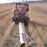
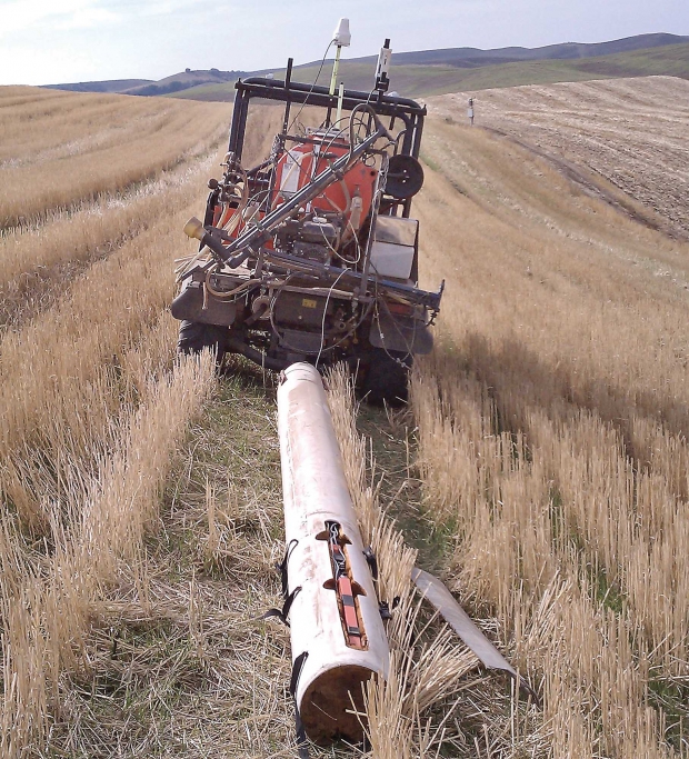
An electromagnetic-induction instrument measures soil conductivity, which is related to moisture, salinity, and clay content. It can be towed behind an ATV. (Courtesy Dave Brown, WSU)
Precision agriculture technologies that are currently available and might be useful in orchards include:
Electromagnetic induction: An electromagnetic-induction instrument, such as the EM38, measures soil conductivity, which is related to moisture, salinity, and clay content. The instrument can be towed behind an all-terrain vehicle equipped with GPS to systematically map the area.
The induction instrument is frequently used in beet farming to test for salinity and can also indicate significant differences in soil depth. Dr. Dave Brown, Washington State University soil scientist, said growers would need to take soil samples to understand the differences in readings from the instrument.
The technology is widely used by consultants. It would normally be done a couple of times the first year, but would not need to be done again on a regular basis.
Near IR probe: Visible-near-infrared spectroscopy, which involves shining a light onto the soil and measuring the reflected light, can indicate the mineralogy of the soil and the organic matter content, which relates to the cation exchange capacity. The device is used with a penetrometer. Brown likens it to an “inverse periscope” that can be stuck into the ground to find out what’s happening, instead of having to take core samples. Resistance to the tip of the device can give an indication of soil depth.
Brown said a commercial field version would be too expensive for a grower to justify buying one.
“This is not something that a grower would have,” he said. “It’s something that a consultant would have, and go out and map your field one time and be done with it.”
Remote sensing: Plants absorb visible light when they are photosynthetically active. Satellite imagery, combined with the Normalized Difference Vegetation Index, can indicate how photosynthetically active the vegetation on the farm is, based on the amount of light absorbed. Brown said dry or stressed areas on a farm can show up on the images before they’re visible to a human being. The technology could pick up certain parts of the orchard that might be stressed by disease or improper irrigation.
Several satellites, such as Landsat, Spot-5, or RapidEye can provide these services. RapidEye imagery includes an extra “red edge” band between red and near infrared in the electromagnetic spectrum, which helps to quantify leaf chlorophyll content and potential nitrogen deficiencies. RapidEye imagery can cover a large area with a five-meter pixel resolution and can revisit daily.
Brown expects that there will be a move away from using satellite imagery toward using ATV- and drone-mounted sensors.
Lidar: This is remote-sensing technology, normally used from an aircraft. It measures distance by illuminating the target with a laser and measuring how far the beam goes down and bounces back up. The name comes from a combination of “light” and “radar.” It generates high-resolution images, including contour and three-dimensional maps. It is often used in forests to make 3-D images of the canopy to assess biomass. It is also used to measure erosion and landscape evolution, where gullies are forming, for example.
Terrestrial laser scanning: The Lidar technology can now be used on the ground, rather than in the air, which brings the accuracy of the 3-D images down to one millimeter. That’s a sharp enough resolution to see veins on a leaf. The laser device can be oriented horizontally or vertically and could be put on a platform or post, or driven through the orchard. Brown sees potential for this to be used to map fruit on the trees. “The fruit would jump out because they have a very different shape from the leaves,” he said.
Terrain modeling: Open-source software is available that can generate insolation maps, showing how much sun exposure and solar energy each part of the farm receives. It is based on digital elevation and slope gradient maps along with calculations of the angle of the sun combined with the angle of the ground surface. Brown thinks this could be valuable information for orchards and vineyards, particularly relating to fruit maturity. It can also detect low areas and wet spots, where water tends to move to.
Drones: Drones have potential for flying low over the farm with sensors whenever needed. Though they are very stable, the helicopter-type drones don’t operate well in wind because they don’t have enough boost, Brown said. But the major obstacle to their commercial use is uncertainty about how they will be licensed. He expects that the Federal Aviation Authority will issue rules this winter to address safety concerns, such as the risks of interfering with aircraft or crashing to the ground and hitting someone.
“People are chomping at the bit to use these tools,” he said. “It’s just hard to figure out how to get them licensed.”
Spacial interpolation: Spacial interpolation software is used to process data collected by the various sensors in order to generate continuous maps from a limited number of data points. It assumes a greater likelihood that locations close to a data point are similar in value than locations further away. •


Leave A Comment